High fire risk today in Rodopi – Access to forest areas restricted

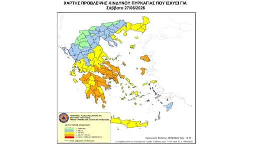
The Civil Protection General Secretariat, under the Greek Ministry of Climate Crisis and Civil Protection, has issued a high fire risk warning for the Rodopi region today. According to the latest Forest Fire Risk Map, Rodopi is classified at level 3 (high risk).
As a precaution, access to several forested and green areas in Rodopi has been temporarily banned for both vehicles and pedestrians. Exceptions apply only to residents, workers, and those traveling along designated roadways. This measure is in accordance with Article 130 of Law 4926/2022.
Restricted Areas Include:
Nimfaia Forest, Municipality of Komotini
Oak Coastal Area, Municipality of Komotini
“Profitis Ilias” Rest Area, Municipality of Sapes
Sapci Urban Forest, Municipality of Maronia-Sapes
Imaret Tourist Forest Area, Municipality of Maronia-Sapes
Kapsala (Imaret) Coastal Forest, Municipality of Maronia-Sapes
Krioneri Coastal Forest, Municipality of Maronia-Sapes
Public Safety Advisory:
Residents and visitors are urged to avoid any activities that could spark fires, including:
Burning dry grass or plant debris
Using spark-producing tools such as welding machines or grinders
Lighting barbecues or open flames
Using smoke in beekeeping practices
Disposing of flammable materials like cigarette butts
Moreover, burning agricultural fields is strictly prohibited throughout the fire season.
In the event of spotting a fire, citizens should immediately call the fire brigade at 199.
For more information and safety guidelines, visit: www.civilprotection.gov.gr