Adverse weather conditions to prevail in Greece in the next days

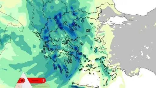
Athens National Observatory's meteo service warned that the weather will worsen from Friday evening and in the next two days.
Heavy and locally persistent rain and thunderstorms are expected, local hail, mainly in the west, central and south, snow in the continental mountains, as well as in lower-altitude areas of western Macedonia, very strong southerly winds on Saturday 30/11, stormy northeasterly winds in the northern Aegean, Thermaikos and in areas of Macedonia (mainly in the regions of Halkidiki and Pieria) from the evening of Saturday 30/11.
The cause of this weather change will be an atmospheric disturbance in the upper atmosphere which is expected to be cut off from the general atmospheric circulation and move slowly, first towards the southern Ionian, and then towards the southern Aegean. The slow movement of the cold lake and the barometric low associated with it will result in the manifestation of strong and persistent phenomena in many areas of the country.
The western and southwestern mainland, the areas of the eastern mainland that are wet by the Aegean, Evia, the Sporades, Halkidiki and parts of central Macedonia will be more affected. However, the phenomena will be significant in the rest of the country, with the exception of Thrace.
On Monday 02/12 the intense phenomena will be located in the eastern and southern countries in the Cyclades, Crete and the Dodecanese, while we expect an improvement in the weather from Tuesday 03/12.
According to the Rainfall Classification Episode (RPI), which is implemented by the Meteo Unit of the National Observatory of Athens, the expected rainfall episode is classified as Category 5 (Extreme).
ΑΜΝΑ


